1 Rice in Italy
It has been a while that, for work and for personal interest, I wanted to explore Italian rice production.
In Northern Italy rice is a very important crop and a very important food.
When thinking of Italian food, the first dishes that come to mind might be the wheat based pizza and pasta, but rice, especially in the form of risotto in the northern regions is a pivotal dish of this area. Risotto is indeed a very famous Italian rice based dish, but there are many other, for example cold rice salads for the summer, risi e bisi (rice and peas) for the spring, or, more typical from southern Italy: the Timballo di riso, which is a baked rice dish with various fillings, or, the best of the best ;), the Arancine, which are fried rice balls typical of the Sicilian street food tradition.
Indeed, rice is used throughout Italy, it was first imported in the south, but it is in the north where rice is most radicated in the culinary and agricultural tradition. Rice was cultivated in northen Italy at least since the 15th century. Italian rice varieties were bred here, adapting them for high latitude and temperate growing conditions, and for our culinary tastes.
There are many aspects of Italian rice that are worth exploring: its history, its genetic pools, the characteristics of the plant and of its grain and its part in Italian culinary tradition. Here I decided to start from the areas in which rice is cultivated.
2 Searching Open Data
To explore and quantify where rice is cultivated in Italy, I had to search for at least two kinds of data.
- Data about agriculture, quantifying how much land is dedicated to which crop/to which kind of farming, and hopefully how much rice they produce.
- Geographical data, to aggregate agricultural data on a map.
2.1 Agricultural data from Regione Lombardia
Lombardy is the administrative region in Italy that has Milan as capital. It’s where I’m staying right now, and it’s also one of the main rice producing regions
It turned out that this region maintains highly detailed datasets on its open data website, about many topics, including agriculture.
And when I say “highly detailed”, I mean it. I was plotting some of their shapefiles to figure out what they stored, and I was puzzled when the resulting shape was a square. I realized that the square was one single farm/field. The dataset that I was exploring contained the shapes and coordinates of every farm field in Lombardy, together with what is cultivated on it!
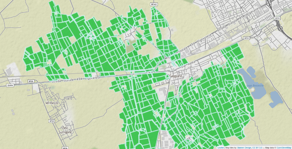
For example, this is every area dedicated to agriculture/farming in Gaggiano, a municipality south west of Milan. (The image below is a screenshot of a leaflet app, here you’ll find the code to download the data and launch the interactive app.)
Associated to the shapefiles, at the same website there is a dataset that stores details of what’s cultivated in each field. With this dataset I could estimate how much land is dedicated to rice production, for each municipality of Lombardy. Here you can find the script for those steps.
I wanted to visualize the area that is dedicated to rice production in each municipality of Lombardy with a Choropleth map. But to do this, I needed a file with shapes and coordinates of the municipalities.
2.2 Shapefiles of Italy on ISTAT
The Italian Institute for Statistics, ISTAT, maintains shapefiles of administrative areas at various administrative levels.
You can use this script (the same as above) to download and merge the shapefiles dataset with the one that stores rice production. In this script you can find also all the options and the details on how to launch the leaflet app below, with the map of rice farming in Lombardy:
library(tidyverse)
library(sf)
library(leaflet)
load("_data/lom_rice_shapes.Rdata") #content/post/
load("_data/lom_cloropleth_options.Rdata") # options for leaflet
m_lom <-
leaflet() %>%
setView(lat = 45.6, ln = 9.7, zoom = 9) %>%
addTiles(urlTemplate = "//stamen-tiles-{s}.a.ssl.fastly.net/{variant}/{z}/{x}/{y}.{ext}",
attribution = attribution,
options = stamen_options) %>%
addPolygons(data = lom_rice_shapes$geometry,
fillColor = pal(lom_rice_shapes$rice_dens),
stroke = TRUE,
weight = 1,
color = "#2D408F",
fillOpacity = .8,
label = labels,
labelOptions = percent_label) %>%
addLegend(pal = pal,
values = lom_rice_shapes$rice_dens,
labFormat = labelFormat(prefix = "", suffix = "%",
between = ", ",
transform = function(x) {100 * x}),
title = "Land dedicated<br>to Rice\nProduction",
position = "bottomright")It looks like most of rice fields are located in the South-West of Lombardy. Indeed, the northern part of Lombardy is mostly industrial and then mountainous. On the South-East there is some rice production, but it looks like most of farming there is dedicated to other kinds of products, maybe foraging grasses or corn, or maybe animal production (I’ll have to check the details, maybe in another post). The South-West area, where rice is cultivated starts from Milan in the north, and extends to the south toward the towns of Lodi and Pavia and to the West toward the towns of Vigevano and Mortara. Most of rice productions seems to be concentrated in that parts of Lombardy that extends and protrudes like a horn into the nearby region of Piedmont.
Moreover, judging by the intensities in the map, it looks like rice production might extend well into Piedmont, the administrative region West of Lombardy. Indeed Vercelli, the Piedmont city right next to the horn, is known as an important center of rice production.
But where to find open data about Vercelli and Piedmont?
2.3 Data from Enterisi
After a quick search from on the open data websites of the Piedmont Region and of the Italian Institute for statistics, I could not find anything as detailed.
Eventually I discovered the Ente Nazionale Risi (National Agency for Rices) and the kind of information it provides. Ente Nazionale Risi is there to support rice farming. And besides providing technical support to rice farmers, it supports the rice market providing incredibly detailed statistical reports on rice production and rice prices. Thanks to that we can continue explore where rice is grown in Italy.
The files with rice production by municipality must be downloaded manually from their database, afterwards, the data can be aggregated and merged to the shapefiles with this script and served to the usual leaflet app.
# options
load("_data/italy-rice-choropleth-options.Rdata")
# shapes and data
load("_data/italy-rice-choropleth-shapes.Rdata")
m <-
leaflet() %>%
setView(lat = 45.30, ln = 8.60, zoom = 10) %>%
addTiles(urlTemplate = "//stamen-tiles-{s}.a.ssl.fastly.net/{variant}/{z}/{x}/{y}.{ext}",
attribution = attribution,
options = stamen_options) %>%
addPolygons(data = rice_shapes$geometry,
fillColor = pal(rice_shapes$rice_dens %>% units::drop_units()),
stroke = TRUE, weight = 2,
color = "black",
fillOpacity = .8,
highlight = highlightOptions(weight = 5),
label = labels,
labelOptions = percent_label) %>%
addLegend(pal = pal,
values = rice_shapes$rice_dens %>% units::drop_units(),
labFormat = labelFormat(prefix = "", suffix = "%",
between = ", ",
transform = function(x) {100 * x}),
title = "Land dedicated<br>to Rice\nProduction",
position = "bottomright")This data are from 2017 and they records the municipality where the farm is registered, while the field can be actually in another municipality. So, these map might differ slightly from the one above (the map with only Lombardy), but hopefully not much. because. This is stated by the source website.
3 Conclusions
From the map above we can notice that Vercelli is indeed the center of Italian rice farming and production. Rice is cultivated in the whole area surrounding this city.
This area is flat and humid. It is the valley of the Po river which runs from the Alps at the border with France, it passes south of Vercelli and Milan and goes all the way o the Adriatic sea, next to Venice. The rice cultivated area is mostly north of the Po river, and it Extends all the way to Milan until Lodi.
Other, smaller, areas rice cultivated in Italy are: the delta of the Po river, and some fields in Sardinia, Sicily and Tuscany. But all those are are cultivated at a lower intensity then the area of Vercelli, Pavia and Milan.
Which aspect of Italian rice would you like me to explore next? I was thinking about the genetics of Italian rices: where do they come from and what are their genetic peculiarities?